Below are listed few of the basic terminologies commonly used in directional drilling-
Inclination-

Inclination is the measurement of angle (in degrees) between true vertical (local gravity vector) and the well bore axis at any given point.
Inclination values varies from 0° (for vertical well) to 90° (for horizontal well).
Plot of inclination values can be seen from Section View or Vertical Plot and type of well-profile can be depicted from it.
Azimuth (or Direction)-

Azimuth (or Direction) is the angle in degrees between the horizontal component of the well bore axis and the reference north.
Azimuth value varies from 0° to 360° in clock-wise direction.
North is represented as 0° or 360°.
East as 90°
South as 180°
West as 270°.

VERTICAL PLOT/ SECTION VIEW
Measured Depth (MD)-
It's the depth measured along the actual well bore from the surface reference point to the survey point.
MEASURED DEPTH, INCLINATION & AZIMUTH ARE THE SET OF MEASURED DATA FROM WHICH OTHER VALUES CAN BE CALCULATED.
True Vertical Depth (TVD)-
TVD is the vertical depth measured from the surface reference point to the survey point.
This depth is always calculated from the deviation survey.
Kick-off Point (KOP)-
KOP is the point in the well bore where change in inclination and orientation of well in a particular direction is initiated.
Building Section-
Building section ranges from KOP to the point, along measured depth of the well where maximum planned angle of the well is achieved.
End of Building Section (EOB) is the point along the measured depth of the well, where maximum planned angle is achieved and it marks the completion of building section or start of Holding section.
Vertical Section (VS)/Departure-
VS is the perpendicular distance (or shortest distance) between the survey point and the vertical axis from the rig's surface reference in a Vertical Plot/Section View.
Build-up Rate (BUR) or Drop-off Rate-
It's the rate at which change in inclination occurs and is calculated from one survey point to another survey point.
Build-up rates are shown in +ve.
Drop-off rates are shown in -ve.
They are measured in deg/100 ft or deg/30 m.
Turn Rate-
It's the rate at which there's change in the direction of the well bore and is calculated from one survey point to another survey point.
Turn rates are shown in +ve if the azimuth turns to right from the previous reading and -ve if left.
They are measured in deg/100 ft or deg/30 m.
Holding (or) Tangent Section-
Holding section specifies to the portion of the well bore along the measured depth where, there is no change in inclination and/or azimuth.
Generally it ranges from End of Build (EOB) to End of Hold (EOH) or Start of Drop (SOD).
Tangent (or Drift) Angle is the inclination of the holding section of the well.
It's also referred as tangent section because it forms tangent to the arc formed by building or dropping section of the well.
Dropping Section
Dropping section refers to the portion of the well from where there's start in decrease of inclination to the final decreased inclination.
Generally. it ranges from End of Hold (EOH) or Start of Drop (SOD) to End of Drop (EOD).
Dog leg & Dog leg Severity (DLS)-
Dog legs are referred as the crooked place in the course of well bore where profile of the well changes rapidly. High dog legs are generally associated with unwanted problems in the hole.
In directional drilling, since the changes in the well bore profile are made intentionally there has to be ways of measuring these changes.
Dog leg severity measures the changes in inclination and/or azimuth from one survey point to another survey point.
It's measured in deg/100 ft or deg/30 m.
North/South (N/S) and East/West (E/W)-
North is a +ve number that indicates the distance NORTH from the rig location, while a -ve number indicates a distance SOUTH.
East is a +ve number that indicates the distance EAST from the rig location, while a -ve number indicates a distance WEST.

Eg:
N/S & E/W values will be respectively,
- +ve & +ve if well direction lies from 0° to 90°.
- -ve & +ve if well direction lies from 90° to 180°
- -ve & -ve if well direction lies from 180° to 270°
- +ve & -ve if well direction lies from 270° to 360/0°
Closure Distance (CD) & Closure Direction/Azimuth (CA)-
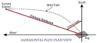
Closure Distance & Closure Direction is the distance and direction of a straight line drawn from the surface reference of rig location to a rectangular co-ordinates on a horizontal plane.
In general,
VS/Departure/Drift will be approximately equal or near to the CD values.
Latitude & Longitude-
They are the imaginary lines on the surface of the earth running from North-South (longitude) and East-West (Latitude).
These are used to represent the GEOGRAPHICAL CO-ORDINATES of the well.
These are used to represent the GEOGRAPHICAL CO-ORDINATES of the well.

COMPARISON-
LATITUDE
|
LONGITUDE
|
|
Direction
|
East-west, parallel to the equator
|
North-south; converging at the poles and widest at the equator
|
Parallel lines
|
Yes
|
No
|
Range
|
0 to 90° North and South
|
0 to 180° East and West
|
Denoted by
|
Greek letter phi (Φ)
|
Greek letter lambda (λ)
|
Hemisphere
|
All locations along a common latitude fall in the same
hemisphere of the earth (northern or southern)
|
Locations along a common longitude may be in different
hemispheres.
|
Denotes distance from
|
Equator (north or south)
|
Prime Meridian (east or west)
|
Time zone
|
Locations that share the same latitude do not necessarily fall
into the same time zone
|
All locations on the same longitude fall in the same time zone
|
Number of lines
|
180
|
360
|
Notable lines
|
Equator,
Tropic of Cancer, Tropic of Capricorn |
Greenwich Meridian
|
Applications
|
Classifying temperature zones
|
Classifying time zones
|
What about tool faces????
ReplyDeleteThanks for your interest, will be posting about it in next posts..
DeleteKeep visiting..
good job sunny
Deletegood job sunny
DeleteThanks... plz keep visiting
ReplyDeleteGreat � I should certainly pronounce, impressed with your site.
ReplyDeleteI had noo trouble navigating through aall tabs as well as related
information ended up being truly simple too do to access.
I recently found what I hoped for before you know it
in the least. Reasonably unusual. Is likely to aappreciate it for those who add forumss or anything, sit theme .
a tones way for your customer to communicate. Nice task.
Thanks for viewing up such helpful information. I like this post, keep update and give the useful post.
ReplyDelete